The leading enterprises in the use of cartography and location data differentiate themselves from their competitors through a superior customer experience, sales performance, and operational efficiency. What if you too were to put geographical intelligence at the heart of what you do?
Geographical intelligence (or geo-intelligence), is the art and practice of using cartography and the geographical aspect of data (both in-house and third party) to improve an organization’s strategic management and operations. Meaningful studies on this subject are sufficiently rare to pay attention to the one conducted by BCG in 2020 encompassing 520 enterprises. Commissioned by Google, this study covers 4 countries (United States, United Kingdom, Singapore and India) and sheds valuable light on:
- the extent to which geographical intelligence has penetrated 5 sectors of activity (financial services, retail and e-commerce, logistics and delivery, real estate, travel and tourism);
- the types of applications, from the most traditional to the most innovative;
- the benefits and outcomes achieved by enterprises depending on their level of maturity in the strategic and operational use of cartography and data location.
If you were going to take only one thing away from this study’s findings, it would be:
- 71% of managers consider that location data is already playing a very important role in their company’s performance.
- 91% consider that this role will be even more important in the next 3 to 5 years.
To quote one of the managers operating in the financial services sector questioned by BCG:
“6 or 7 years ago, I would have told you that having geo-spatial data is useful. Nowadays, for a company such as ours, it is indispensable in growing turnover and personalizing the customer experience.”
Whereas BCG focuses on location data and geo-spatial data, we emphasize the fact that all data can be located, namely 

 , which is the starting point for all
  .
.
Before delving deeper into the contents of this study, we should note that the word “geo-location” does not appear once in the BCG report. Purists will appreciate the absence of what could be considered, if not tautology, at least an undue overgeneralization. Inasmuch as location is inherently geographical, the prefix “geo” is indeed superfluous – unless in using it one wishes to emphasize that the data enabling an object/person to be accurately pinpointed on the planet Earth originates from a satellite system. In other words, when you place your customers on a map, you are locating them (from their address). When you track your field teams by GPS, you are geo-locating them (from geographical coordinates transmitted via GPS).
Do you know the 8 fields in which geographical intelligence is used?
The enterprises questioned use cartography and location data in more than hundred applications, which can be divided into two groups: on the one hand applications aimed at/relating to the company’s customers; on the other hand, operational applications. Each group comprises four broad categories of applications.
The table below recapitulates the 8 areas of use, showing, for each sector, the percentage of enterprises that have deployed applications in the various areas.
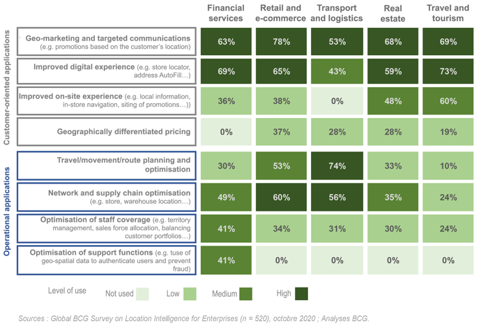
If you are familiar with GEOCONCEPT, you already know that our solutions cover all these areas. But have you explored all the possible uses within your company? Are you exploiting the geographical dimension of data in all businesses and activities where it can add value and improve your performance? Ask yourself the question because, according to the BCG’s analyses, this is exactly what geographical intelligence leaders are doing.
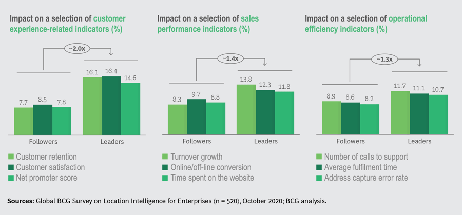
What sets geographical intelligence leaders apart
For the BCG, the leaders are the enterprises that are the most mature in their use of cartography and location data and which, as such, derive the greatest value from it. They represent 15% of the sample that was questioned and are characterized by:
- An all-encompassing and strategic approach to geo-intelligence tools and methods. They maximize the synergies between their geographical intelligence applications to enhance the customer experience and improve operational efficiency.
- Systematic measurement of the value generated by the applications. They quantify their objectives and put in place dashboards enabling them accurately to track the results achieved.
- Strong analytical and data management skills (capture, integration of multiple sources, modelling…).
- Partners carefully selected for their knowledge and mastery of deploying geographical intelligence platforms, the openness of their solutions, and ability to integrate these solutions into the existing IT infrastructure.
- Proactive protection of their customers’ data, in particular movement-related data provided by mobile systems.
- Mastery of the fundamentals of geographical and cartographic applications (production of high-quality maps, accurate geocoding, accurate location data…) enabling enterprises to innovate and develop more sophisticated applications.
All of this translates into significantly superior results to those observed among enterprises just  – those the BCG calls “followers”, which represent 30% of the sample (the remaining 45% are described as “challengers”). On a selection of indicators, the leaders do up to twice as well as the followers thanks to their mastery of geographical intelligence:
A few of the results mentioned by the enterprises questioned:
- A 4% reduction in online order delivery costs thanks to dynamic route planning (retail)
- An increase of between 4 and 7% in the number of deliveries by driver thanks to route optimization and an 11-point increase in satisfaction once customers can track the delivery vehicles’ itinerary (logistics)
- 2-minute improvement in estimated delivery time, translating into a 30-minute gain per day for each of the company’s 1,400 drivers (beverage delivery)
- 15% increase in the average shopping basket by targeting promotions using customers’ location data (retail)
- 108% increase in hotels viewed by customers thanks to the website’s dynamic map search function and a 12% increase in the conversion rate after viewing (hotel chain)
Not all these examples are spectacular, but these  do make the difference in these especially competitive sectors – all the more so in the current economic context.
That being so, whatever the sector you are operating in, do not neglect the geographical dimension of your data. 


 you create for your customers. Above all, give your operational teams the wherewithal to leverage location data easily to save time, cut costs, increase sales, analyze your geographical footprint, improve service quality and, ultimately, make the difference in your customers’ estimation!
