Even the smallest street in any of Switzerland’s towns and cities has a territory information system (TIS)… a vital tool for managing day-to-day operations, meeting the challenges of tomorrow’s world, and offering innovative services for the local population…/em>
Geomatics engineer Isabelle Besson plays a pivotal role in Geoconcept’s Swiss subsidiary. An expert in Geoconcept’s Edilis solution, she explains how French-Swiss town authorities centralised geographic information, how they use it, and how they share it with residents.
How has it come about that Swiss town authorities all seem to be equipped with a Territory Information System?
Historically, local authorities started to equip themselves with TIS at the end of the 1990’s when the confederation offered financial subsidies to help them achieve this aim, in the context of a national project to build an underground sanitation network. However large or small, communes were obliged to go down this route, and so it came about that we developed the Geoconcept solution Edilis, fully installed with an off-the-shelf data model that allowed them to rapidly create their sanitation plan and maintain it day-to-day, but more broadly, to centralise and map all the data needed to set up a comprehensive system for managing their territory, equipment and communal heritage.
More recently, in 2007, Geoinformation law (Lgeo) set new rules about the capture, update and management of geodata and metadata sourced by federal, canotonal and communal authorities. This law streamlines data and metadata formats in Switzerland, but also obliges communes to make certain categories of territorial data available to the public via a cartographic terminal or portal.
So in short, Swiss communes had a strong incentive to equip themselves with this technology. But over and above any obligation, I really believe they adopted these tools because they understood just to what extent this centralisation of data could help them in their three essential missions: to inform, manage, and plan.
Communes adopted these tools because they fully grasped how centralising their data could help them move accomplish their three essential missions: to inform, manage and plan
Geoconcept’s Edilis Territory Information System (TIS) is used by some 150 communes in French Switzerland. What kind of data are they using?
The foundation layer is the cadastre. This is the baseline: without the cadastre, there would be no map of individual land parcels or plots, roads, buildings, addresses… In short, you wouldn’t have any means to geolocate information spatially, this being the starting point of any geographic application. As soon as you have this base layer in place, you can add as many additional data layers as you need: land use, water supply networks and other supply networks, green spaces, public lighting… To make it easy to get started, we supply local authorities with a catalogue that currently covers 25 themes….
Communes choose their own mapping themes depending on their obligations, priorities, and the specifics of their territory. Each town or commune can, of course, develop their own specific areas of interest to inform their current projects or requirements. For our part, we are constantly adding to our catalogue as and when new issues come under the spotlight, or as new legal obligations appear.
How is the Territory Information System used by authorities?
A Territory Information System (TIS) is a data handling tool designed to assist authorities with daily management and decision-making. The fact of  and view any object in a territory on a map provides those responsible for town planning and development with an overview of the sum total of the city’s heritage, property and installations. Since the information form for each object contains all the object’s relevant attribute information, the TIS is effectively a comprehensive database and the window into the detail and characteristics of all things relating to the territory in question. This ranges from the status of a particular land parcel or plot, to a lamp-post’s make, model and installation date, the map positions of bus stops, the slope and diameter of pipeline sections, or even the state of health of individual trees! The commune of Rolle, for example, has records of no less than 27 information items for each tree, and a photograph.
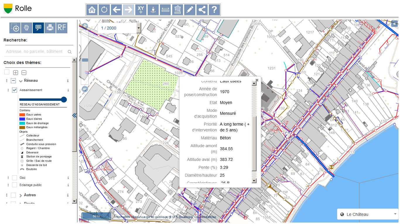
Geoportal for the town of Rolle (in the Vaud canton) – 6,246 inhabitants (2018). Water and sanitation network. Each section is described in a form providing about fifteen information items, including the slope and diameter of every conduit https://rolle.edilis.net
Communes use their TIS daily to inform and manage building permit requests, and to 

 . But it is also a precious tool to plan renovation or maintenance work, and rationalise the related budgets. A real-life example of this is where a water sanitation network with a shallow slope needs to be treated regularly. A machine has to be passed through the drainage system to eliminate gravel and accumulated waste material that risk clogging it up. Sending the query via the TIS, the commune can rapidly identify all collectors with a slope of less than 1%. It shows where the section joins are located, calculates the number of linear metres concerned, and can, on this basis, and as a function of the available budget, take a decision to treat and maintain 1.5kms this year in such and such a sector, 1.5 kms next year in another sector, etc…
Another example, in the area of town development this time: deciding where to create soft mobility zones, and bicycle stands… Answering this question – one of keen interest currently in numerous communes – will involve looking at existing car parks and public transport hubs or stops, and delimiting 3-5 minute walking areas around these points, since we know that people are reluctant to walk longer distances… We can see immediately which zones are less well served, and where it might be useful to install more bike stands or other street furniture to encourage soft mobility with cycle paths, footpaths, charging terminals for electric cars, sheltered car parks for cycles or pavement scooters…
Are communes or cities autonomous in the deployment, development and utilisation of their Territory Information System?
This will depend to a large extent on the commune size and the type of solution chosen. Some major cities can have all the competencies they need in-house, but what I actually observe is that many of them resort to appointing an agent or expert who is specifically in charge of integrating and updating their data. Smaller cities always enlist outside support or consultants, and of those who have chosen our solution, they are tending now to opt for the cartographic portal than for a desktop solution. This 100% online formula, based around the  , allows them to meet all internal needs with a single tool, and also to meet their obligation to publish information for easy access by the population at large. Finally, for teams working in the field, we have a mobile version of the solution. This is used, for example, for direct data capture when compiling inventories of tree plantings , urban furniture or other ‘moveables’.
Whatever the size of the commune, the real advantage of the portal is that it can filter out any sub-adjacent complexity, so personnel from the various city services can be autonomous in their daily utilisation of the TIS. Those in charge of green spaces use it to structure and optimize their maintenance schedules. Green space teams can consult the characteristics of the parks or green spaces they are going to work on, so they can always arrive on site with the right equipment. The council employee to whom an inhabitant flags up a non-functioning item of public lighting, can, by typing in the name of the person or their address, immediately locate the lamp post concerned, and request their technical staff to go out and repair in the shortest possible timescales. I could cite a thousand more examples where rapid access to geographic information contributes to greater efficiency in managing every aspect of local services and permits faster response times when processing incoming queries and requests.
Rapid access to geographic information contributes to more efficient management and greater responsiveness on the part of local services to citizens’ requests.
What are the issues of current concern for the cities and towns you are working with at the moment?
There is high demand for everything related to the environment. I’ve already talked a bit about soft mobility, and green spaces and heritage inventories, but there is also a requirement to map zones where road noise is an issue, and hot and cold weather zones to identify areas where solar potential indicates roofs of buildings could usefully be installed with solar panels. Towns or cities carry out studies on the ground and update measurement data in the TIS. On the Ecublens geoportal, for example, any citizen can consult the data to see instantly whether or not investing in solar panels would be worthwhile.
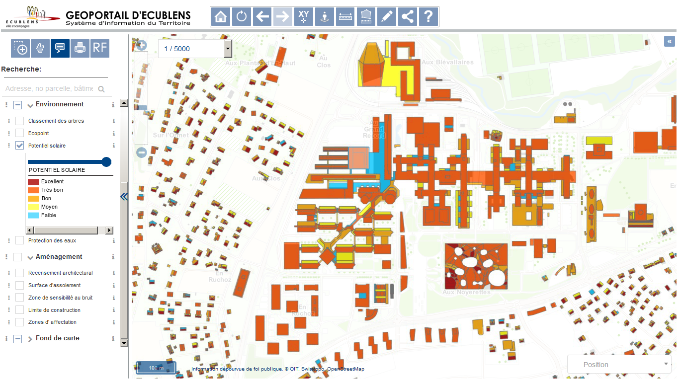
Geoportal for the Ecublens commune (Canton de Vaud) – 12,939 inhabitants (2018). Solar potential map. https://map.ecublens.ch
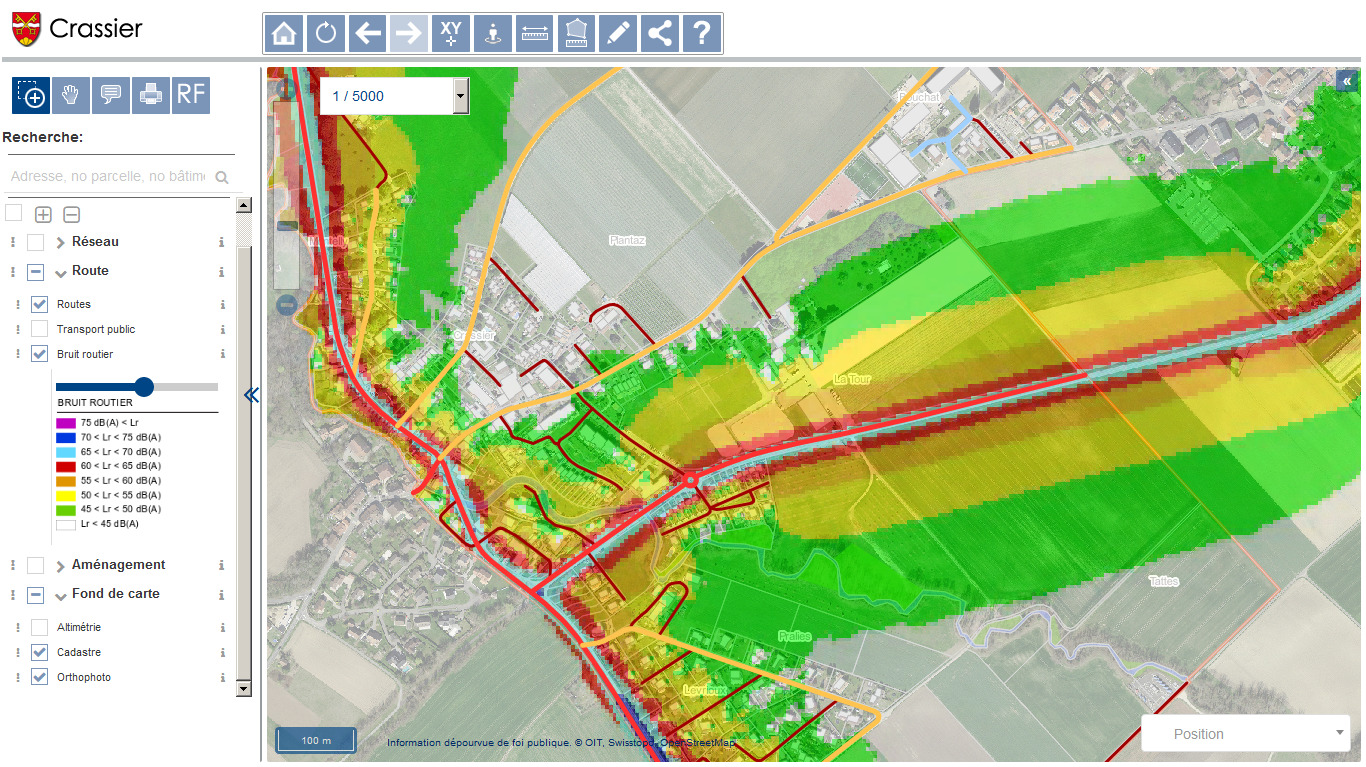
Geoportal for the Crassier commune (Canton de Vaud) – 1,175 inhabitants (2018). Map of the road network and road noise. https://crassier.edilis.net
We are also seeing a rising number of more sophisticated requests relating to waste disposal. Some communes are starting to equip themselves with public waste containers fitted with sensors that send a signal when the container is full and needs emptying. The objective is to  , notably with the help of other tools in the Geoconcept range. Simmilarly, we have communes seeking to

 . Many of these routine tasks are still performed manually, but the development of intelligent objects is becoming a reality.
The notion of the «Smart City» – with all this implies in terms of localisation of equipment, and real-time data processing and publishing – will assume ever greater importance.
This is a step change that will significantly help communes
 , and offer new services to inhabitants, such as being able to consult in real time to find out where parking spaces are available in a city centre. The notion of the «Smart City» – with all this implies in terms of localisation of equipment, and real-time data processing and publishing – will assume ever greater importance. And – it goes without saying - we are already working on these precise themes as we continue to support communes and supply the solutions they need, as we have done for more than twenty years.

